
 Land Acknowledgement: Place Based Histories and Indigenous Leadership, 88 x 68″, craft paper, acrylic paint, collaged colour prints, pencil crayons, marker, gouache, Scarborough Centre for Alternative Studies, Toronto, 2018-2020.
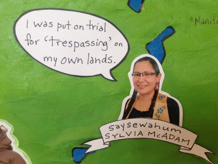
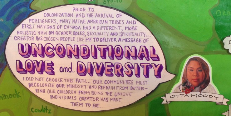
Images of Indigenous leaders depicted in this project, and their quotes, have been used with permission from the individuals depicted, or from their family members.
This project aims to create an awareness of place based histories on this continent. Students painted a map of Turtle Island indicating the territories of Indigenous nations, and they located both Indigenous and colonial place based histories on the map. Each student researched an Indigenous leader and collaged their image into their territory, with a good quote that would be important to share.


Inspired by Vine Deloria’s writings, the shift from time based history to place based history was intended to evoke a more concrete understanding (than what would be learned from memorizing events on a timeline) of Indigenous peoples’ profound connection to the lands here, and of Canada’s colonial history.

To begin, students were asked to project and trace a map of Turtle Island where Canada is situated onto a huge piece of paper that they had stapled to the wall. They then used the Whose Land website to paint the Indigenous territories onto this land mass. Students were forewarned that maps are never 100% accurate so they were not expected to map the territories perfectly; the expectation was to do their best to gain an idea of where the different nations are. Multiple classes took part in this task which required numerous revisions and tremendous perseverance. The challenge lay in the overlapping territories. It was difficult to demarcate a territory from multiple overlapping boundaries and the frustration associated with this undertaking led to the realization that different nations actually shared territories. I wondered about traditional governance systems — land laws — and protocols that could enable this. When Isaac Murdoch visited our school he provided an example by explaining that much of the border between Anishinaabe and Cree territories was established by the flow of water: the rivers which flowed into James Bay were considered to be in Cree territory, while those that travelled into the Great Lakes were considered Anishinaabe.

Maps have been used throughout history as colonial tools for claiming stolen land and they are still used in this way — albeit unknowingly by teachers in Canadian schools. Students’ perception of the land they occupy is shaped by the maps that they are given to conceptualize in the classroom. When Canadian students are directed to depict the provinces of Canada with no regard to the Indigenous territories that they were superimposed upon, their teachers unknowingly maintain a colonial structure that aims to erase Indigenous presence from the land.
When given the task of illustrating the Indigenous territories, students’ notions of Indigenous land from the land acknowledgements became less abstract and more understandable as something real. After engaging in this exercise it became a lot easier to comprehend the fact that Canada is not the only nation here.

While various students worked on the territories, we began learning about Indigenous Place Based Histories. Students made drawings or found pictures of key elements from the stories which showed how Indigenous people have belonged to these lands for thousands of years. They then collaged these images into the map.


After learning about some Indigenous place based histories, students then located Colonial Events on the map. By finding the locations of treaties that were made dishonestly to steal land, in the order that they occurred, along with the locations of impacts of oppressive legislation that was breaking up families and dispossessing Indigenous peoples from their lands, students’ understanding of colonial history increased. Amidst these colonial events, students also located instances of Indigenous resistance which have been continuous since the time of contact.


At the end of June, I took the map home to add finishing touches. I wanted to ensure that there were quotes which conveyed the 5 criteria for genocide that are still occurring today. If students and teachers could see the research in a glance, maybe more people will be likely to take a stand against what is happening. I am hopeful that this will be the case, and I call on educators to take the map challenge and paint the Indigenous territories with their students this year.


This project is on permanent display in the library at Scarborough Centre for Alternative Studies in Scarborough, Ontario. It is a gift to teachers and students to help them learn about our collective histories on this land, and to make decisions that reflect responsible citizenship rooted in truth, respect and love.

RESOURCES & LESSON IDEAS
Click on the links below for curriculum resources connected to this project:
Place Based Histories examples and lesson.
List of Colonial Events and Acts of Indigenous Resistance to read from.
List of Colonial Events and Acts of Indigenous Resistance to cut out for students to locate on the map.
Citations for quotes from the map.
Questions:
1. Cathy Calfchild and Kanahus Manuel refer to genocide in their quotes. Read the United Nations’ document entitled “Convention on the Prevention and Punishment of the Crime of Genocide“. Find examples in the map of how Canada is fulfilling each of the 5 criteria listed in Article II. According to this document, how can genocide be stopped? (Discussion and/or essay)
2. Choose 3 people depicted in the map and find a connection between what they are saying. Have a discussion about it or write an essay about it.
3. Cindy Blackstock urges Canadians to insist on change from the government. How do you insist on something to your government? Figure it out together and do it.
John Morton, founder and principal of the Student School in Toronto once stated in terms of activism, “Make it easier for them to respond than to ignore you.” Once you do your research and learn about the issue, be persistent. Make phone calls every day. Write letters. Organize with other students. Write letters to your MPs.
4. Mylan Tootoosis’ quote refers to emotional intelligence in 2 different ways:
i) He talks about embracing your emotions when faced with ongoing historical trauma, in order to disrupt the colonial system. Explore this process somehow (writing journals, discussions, public speaking).
ii) Do you ever feel defensive or fearful when facing the truth about something bad that you are connected to? How can you work through these feelings in a productive way? How can you use your position as a member of an oppressor group to stop the oppression? Do something real to disrupt the colonial system.
5. Choose a few different quotes from the map and identify one or several articles from UNDRIP that are being violated in the quote.
6. How are current impacts of colonialism shaped by Canadian history? Answer this after locating the different Colonial Events on the map.